Monday, June 27, 2011

Quebec City, Levy, Cap a l'Aigle, Tadoussac, QC - June 22–27, 2011

The next morning, June 22, we set off in the Portland Pudgy for the dinghy dock at the Yacht Club de Quebec (YCQ).  They were very nice and let us leave our bright yellow Pudgy at their dinghy dock for no charge while we went sightseeing in the old walled city of ancient Quebec.
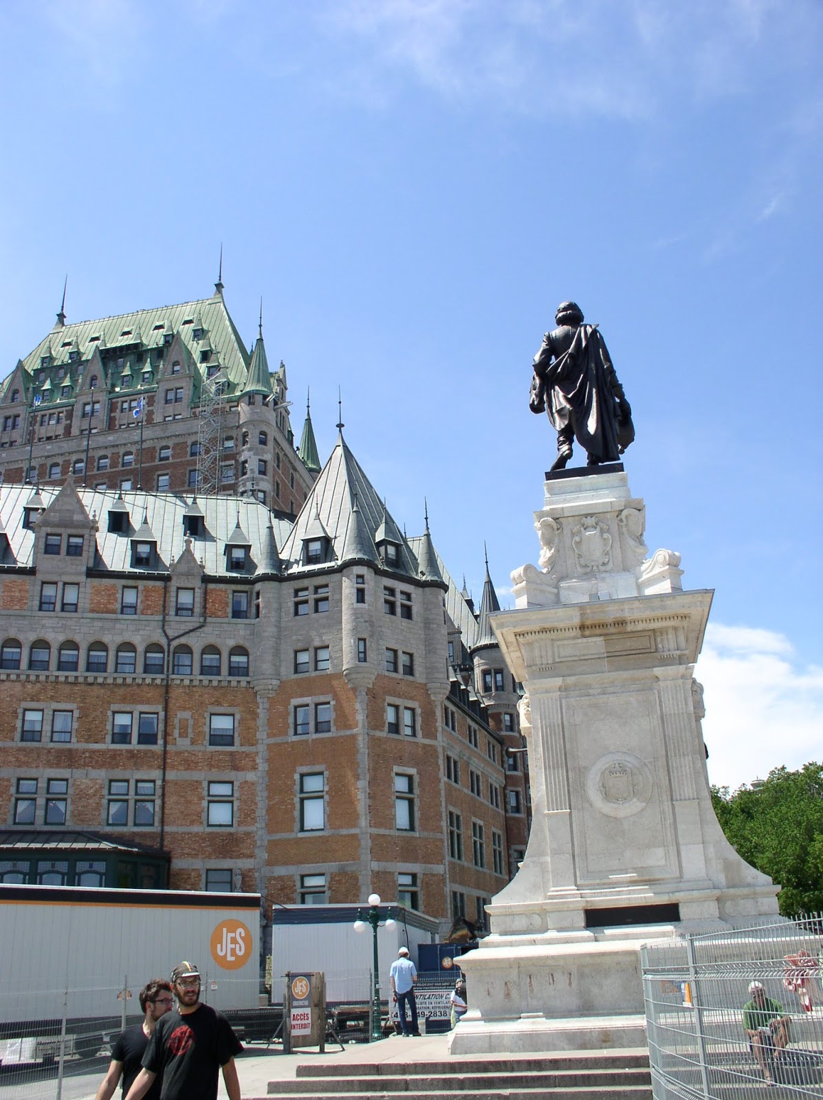
Hotel Frontenac

Ray and I began with a cab ride to the Hotel Frontenac with its astounding edifice overlooking the St. Lawrence River and all of old Quebec City.  The Citadel was very fascinating with its two 15 feet deep ditches or dry moats surrounding the main rock fort.  It truly seemed impregnable, especially when we saw how effective their camouflage worked.  The entire fortress seemed to an approaching enemy to be nothing but a wide rounded hill with some rock fences.  In fact, all the buildings and approaches were below eye level and the few buildings' roofs that were higher that the surrounding ground were all the green copper color which blended into the surrounding “Plains of Abraham”.  It was quite impressive.
Winding streets reminiscent of Europe

While on a free tour of the residence of the Gouverneur General, we met fellow tourists from Ontario, the US, Australia and Holland.  The residence is part of the active military fort that is still in active operation today and hosts foreign dignitaries and domestic heroes regularly.
Quebec City funicular

On concluding our tour of the Citadel we walked down the hill through the walled city and finally into the portion of the old city that was along the river.  There were excellent murals painted on the walls of two large buildings depicting life in the ancient city as it once was.  While walking through this portion of the town, we ran into our new friends from the earlier free tour and swapped stories with the Australians and the citizen of Holland.
Murals appeared 3D on flat walls
Zoom in to appreciate the detail of the "3D" mural

Just a little later, I ran into the brother of an acquaintance from Wabash College.  I was wearing a Wabash shirt and when they asked me about it, we found our common bond.  They live in Massachusetts and invited me to visit when I sail by their area.  Ray and I walked back to the YCQ, about 3 miles.  After relaxing at the club, we dinghied back to Kelly and made our plans to pick up our newest crew, Ed.

The next morning, June 24, we pulled up the anchor and motored across the St. Lawrence River to Parc Nautique Levy, the municipal marina of the town of Levy.
Levy Marina QC
Levy is the suburb of Quebec City directly across the river from Quebec.  It is a smaller city, very friendly, and the people at the marina, both staff and boaters were truly accomodating and most helpful.

Ed showed up after his flight and we got him settled into a berth on board.  The weather was forecast to be rainy with winds from the northeast, so we were not going to be sailing into the nasty waves and wind.  Instead, Ed and I took the Levy ferry into Old Quebec and rode the Funicular (inclined railway) from the waterfront to the Citadel.  We walked in the rain and mist exploring the winding streets and wandered through a gate in the ancient wall to find ourselves in modern downtown Quebec City.  A band was warming up in the plaza so we stopped in the restaurant across the street for a meal.

It turns out that at midnight, Quebec City kicks off their celebration “FĂȘte de la Saint-Jean-Baptiste”, so we saw a terrific fireworks from our slip in the marina.  We also met some terrific people, including a fellow cruiser who calls Levy home.  He will be taking his boat through the NY Barge Canal then down the Hudson to visit New York City in July and August.  I would truly enjoy seeing him again, but the earliest I might get to NYC would be late September and I may not get there until summer 2012.  He was our best friend right from the moment we met.  There was nothing he wouldn't do to help us, including giving me his car keys so we could do some shopping and visit the Levy bonfire & concert for their celebration of Saint-Jean-Baptiste.

While at the bonfire, I met a young couple and after testing my minimal language skills, I noticed that the young man was wearing a Pittsburgh Penguins hat!  He proved to be a fan of all the Pittsburgh sports teams, including the woebegone Pirates.  If the Pirates are doing well at this point, please forgive me.  I haven't checked their activity since leaving Erie.  Ed, Ray and I also found a lady our age who used to own a sailboat and had cruised many places along the St. Lawrence River and Atlantic Coast.  When we ended our conversation, she kissed all three of us on both cheeks as we had seen many French Canadians do with their friends.

Between car trips the owner sat with us and collected several of his friends so the Kelly crew could absorb as much local knowledge as possible about our next few legs down the St. Lawrence.  Of course, we had terrific fun learning French, sharing stories and laughing together as we learned about sailing the St. Lawrence River.

With the overwhelming friendship shown us by our newfound friends in Levy, I can assure all cruisers that Levy is a great place to visit when in this area.

The leg from Levy/Quebec to Cap a l'Aigle is about 77 nautical miles, significantly further than from Erie to Port Colborne.  For that trip we needed over 13 hours.  Since we would be boosted along by some strong tidal and river currents, this leg only required 11.5 hours, meaning that we could do the distance as a day trip, if the timing of the tides was with us.  Our new friends, the guidebook and the books with the current data all made very clear that we would either depart at night or arrive at night.  The timing of the tides was not with us.

Since I prefer to enter new ports (new to me) in daylight, we decided to depart on the appropriate tide after 11pm on June 25.  Making sense of the navigational lights was quite challenging with the dazzling background of city lights on both shores.  We motored into the lightening northeast breeze and small choppy waves.  Even though the motoring in the night was a challenge, our crew carried it off very well.  We successfully identified and passed a freighter in the tight channel to the south of Ile de Orleans as well as 2 other freighters in the wee hours as the first wisps of daylight were trying to break through the clouds and gray mist.
11.3 knots, SOG!  Our speed through the water was 6.5 knots, at this point

As the morning grew brighter we also saw our speed over the ground pick up.  The tide was changing in our favor and while our boat speed through the water stayed about 5.5 knots, our velocity made good increased to well over 10 knots!  We were following a formal watch schedule to be certain that one person had responsibility for the boat at all times, allowing the other crew to get some sleep.  As skipper, I discovered that I had stayed up with each crew as they stood their respective watches, so I was pretty tired after being awake for over 30 hours.  Ray and Ed were both doing very well even though they had only enjoyed short catnaps while off watch.

I took a couple hours to rest and joined the crew in the cockpit as we approached Cap a l'Aigle just east of La Malbaie.
Cap a l'Aigle
We pulled into the slip just behind “Deuce Menace”, a black-hulled beauty of a sailboat.  The woman aboard Deuce Menace came to help us with our lines and we learned they were also sailing from Quebec to Tadoussac and were preparing to depart Cap a l'Aigle just as we were arriving.  We met her boyfriend, Eric, and then said au revoir as we headed to our assigned slip.

Ray and Ed headed to the restaurant for lunch while I stayed with Kelly IV to tidy up and take my lunch on board.  While Ray pursued the local internet connection, Ed and I took a walk up the steep hill from the marina and checked out the “town”.  We discovered that the only restaurant was at the marina and the only commercial activity within walking distance were a few auberge's or small country inns.  The exercise was good even if there proved to be nothing to discover beyond the dramatic view of the now very wide St. Lawrence River.  The opposite side of the river was now over 11 miles away.

To avoid a contrary tide at our next port of call, Tadoussac, we had to delay our departure on June 27 to Noon.  The fast curents helped us make good time as we tried to sail the following breeze.  Unfortunately, it was just too light, so we motor-sailed down the river.

One of our most exciting moments to date occurred when Ray sighted some beluga whales a few hundred yards off our starboard bow.  They were quite far away so we sometimes confused the occasional whitecap with the white belugas.  Suddenly, Ray and Ed were pointing directly aft of Kelly where two belugas whales had just surfaced!  They were only a few yards behind us and coming up fast so they were just under our transom.  Without slowing down the large white mammals dove under Kelly's stern and disappeared under her keel.  The whales were so close, we could see the lines in their skin just a foot or so beneath the surface of the water, before they dove deep.

By this time we were in position to turn north into the Saguenay Fjord and the harbor at Tadoussac.  Fortunately, we saw another pod of beluga whales to our west as we motored north into the dying current and tied up for the night.
Tadoussac

The next morning Kelly and crew were off the dock and motoring northwest into the Saguenay River and Fjord.  The craggy rock cliffs and thin, tall evergreen pines were beautiful.  The sun even escorted us as we pressed upriver away from the St. Lawrence.  Finally about 2pm the breeze increased so we were able to sail wing and wing.  Over the next couple hours the gradual changes in the wind had us performing an occasional jibe and finally we were sailing on a close reach.  It was a wonderful sail, even if it was a brief one.

We had plotted our course using waypoints from Rejean and Helene, who call the Sageunay Fjord home.  Their waypoints took us to a spot immediately below the large white statue of the Madonna, which has been overlooking Baie Eternite' for a hundred years.  After a few pictures were taken, we sailed into Baie Eternite' and picked up a mooring.
Baie Eternite'
The water in the bay is much too deep for anchoring, as is most of the Saguenay Fjord.

On June 29 we dinghied ashore to hike the 3km over the mountain to the site of the Madonna Statue.  It was very steep, but had some terrific and exciting views of the Baie, the mountains, and Kelly IV tugging on her mooring.  It was a cool, damp day, but that proved fortuitous as the cooler temperatures kept us comfortable as we hiked over 200 meters in elevation to achieve our destination at the statue.

Upon our return, we realized that we could just get back to Tadoussac in time to join the marina crowd for some singalong fun at the local pub, if we left right away.  So we hopped into the Pudgy, tied the yellow dinghy into a towing position (faster than raising it into the davits) and motored out of Baie Eternite'.  By 10:30pm we were sitting alongside Celine and Eric as they and the entire crowd in the small pub sang traditional French songs following a guitar and accordion duo.
The Virgin Mary viewed from the River

The forecasted weather was for northeasterly winds, so we couldn't sail to Rimouski, our next stop, until Friday at the earliest, and maybe not until Saturday.  With lots of duties piling up at home and no sailing for the immediate future, both Ed and Ray decided Tadoussac was a good place to take their transportation back home.  By 9am, both were on their way to the bus station.  Sailing with them was a fun and worthwhile experience.  I am glad they were able to join me.  They are good company and helpful sailors.

The Virgin Mary is huge!  My crew is over 6' tall.


The balance of the day was cool and rainy with a lighter than forecasted breeze.  It was time to change the oil as well as tidy up the boat and do some laundry.  With the day being so gray, damp and cool, it was no bother to do the chores. 

In addition, I enjoyed the company of another sailor, tied up near Kelly.  Jim has a 31 foot steel cutter that he gutted to a bare hull and rebuilt in 2001-2003 and he's been cruising on “Steel Farm” ever since retiring in 2004.  Tomorrow, July 1, we will depart together, setting sail for Rimouski, about 55 nautical miles away.

We are now 872 nautical miles from Erie, PA.

Tuesday, June 21, 2011

Batiscan, Quebec City, QC - June 19 - 21, 2011

Departing Sorel, we were excited as we had high hopes for a full day of sailing.  The forecast called for a westerly breeze so with our northeasterly course we planned to be sailing a broad reach.  Our initial course would through some islands at the southwestern end of Lac St. Pierre until we burst out of the river onto a lake setting with the far end of the lake beyond the horizon.  It felt as though we re really were at sea.

In actual fact, we had to follow a channel because the depths in many places beyond the channel were much too shallow for Kelly IV's 5 feet 3inch draft.  Regardless, the channel was mostly over a quarter mile wide and often much more than that.  The wide channel was easy to negotiate in our small vessel, even when under sail.  So we raised the main and jib and sailed the entire length of Lac St. Pierre, about 17 nautical miles.  The breeze actually proved to be out of the northwest and even a little NNW, so we were sailing on a beam reach and sometimes close hauled, but with the flat water and 12 – 15 knot breeze, we had a blast!

Ray and I split the helm duties pretty evenly, I had the helm when we first raised our sails, then Ray finished the final half of the sailing as we approached the very tall fixed bridge at Trois Rivieres.  The breeze seemed to be moving to the north, so we had to drop our sails and motor the last couple hours into the anchorage at the mouth the Batiscan River where it empties into the St. Lawrence.

Although there was probably some current when we were anchored at Long Sault Island, it was small enough to ignore it.  The wind was really the only factor we had to consider at Long Sault.  And anchoring with only the wind to take into account is how I have almost always anchored.  Now at Batiscan, we had to consider river currents for both the Batiscan and St. Lawrence Rivers, as well as the tidal currents of the St. Lawrence River.  According to the guide book, “the current at the mouth of the Batiscan River always sets easterly”.  This meant that the Batiscan River flow was strong enough to overpower the flow of the high tide as it flooded upstream.

As we pulled into the river mouth to select a spot to lower our anchor, a fellow sailor called to us.  He let us know that the Batiscan River does, in fact, reverse its flow at high tide.  On his way back home he rowed his dinghy by Kelly and stopped to chat.  We learned that Gerald was departing in a week or so, taking his boat “Gallop” across the North Atlantic to the Azores, then on to Senegal in Africa.  Suddenly my little adventure seemed pretty tame.  Of course, that is my plan, to keep things pretty tame.  Regardless, it is very exciting to be rubbing elbows with sailors like Gerald.

I decided to stay up a little late and make sure our anchor was OK since the change in the direction of the flow would take place at midnight.  Sure enough, about 11:30pm or so, Kelly IV stopped facing upstream and gradually began to turn until she was facing the St. Lawrence River where the high tide was flowing into the mouth of the Batiscan River.

We saw the same turning at each high tide while we were anchored there.  Since we were making good time, mostly due to good weather and currents running in our favor, we decided to stay two nights at Batiscan.  Our anchorage was right next to a small marina which had a small but very nice restaurant.  Ray and I dinghied in to sample a French Canadian delicacy, “Poutine”.  It is a hot dish of french fires and cheese curds, drowned in beef gravy.  It actually was quite good and that was my dinner for the night.  The owner, Sophie, was very kind.
Sophie
We were her only customers when her last customer left the restaurant soon after we were served.  She let us stay as long as we wanted to and even practiced her English with us, as our French was certainly nowhere near as good as her English.  We laughed and told stories and shared boating dreams and experiences.

The next day, we took our breakfast at Sophie's restaurant and met her waitress, Stephanie.  Once again the food, service and company were all quite excellent.  With our breakfast complete, Ray and I walked  the kilometer into the small town of Batiscan and bought some groceries.  As we were paying, a friendly gentleman asked if were were going to the marina and would we like a ride.  We were even more surprised when he told us he owned the marina and was Sophie's husband.  Apparently, she had told him about us and when he saw us in the store, he realized we must be the characters his wife had told him about.  So we didn't have to carry our groceries, but got a ride right back to our dinghy.

Before we got back to Kelly, we stopped at a two masted schooner anchored just west of us.  The owner invited us aboard and we got to talk with him and look around his schooner.  He and his girlfriend with another crew are planning an August departure for the Azores, then on to Africa!  Four boats were in this anchorage and two were world travelers!

Once back on board, we began to tackle a few minor projects.  Ray secured the small 175 watt inverter so we wouldn't keep knocking it on the floor, while I completed my splicing of the new 75 feet long dock lines.  We also spent some time getting more familiar with the guide book, the sailing directions, tide and current tables and the charts.  Gerald stopped by again to share some of his anchorages that he uses along the St. Lawrence, further downstream.

With some work required at the masthead, Ray volunteered to go aloft.  While he was there he took some great pics from Kelly IV's masthead.
Ray aloft
Gerald's sailboat in the Batiscan anchorage
Kelly's foredeck from the masthead

Kelly's aft deck from the masthead

As the afternoon wore on a very smart looking Southern Cross 28 pulled into the anchorage and dropped their hook just behind (west) of us.  They were the first US boat I had seen since leaving Port Dalhousie.  I called out to them and they invited us over.  Once they got settled, Ray and I took some drinks, climbed into the Pudgy and motored over to visit “Oh My!”.  We discovered that Lee, the owner from Grosse Point, Michigan, had sold the boat to Malcolm, a Newfoundlander.  They and a friend, Jim, were delivering the boat to St. John's, Newfoundland, and had left Michigan on June 2nd.

According to the guide book, we needed to depart Batiscan about 7 hours before low tide at Quebec City, for the best trip avoiding contrary currents.  That meant leaving about 11am, so after a final cup of coffee with Sophie and Stephanie, we returned to the dinghy and Kelly IV.  We waved our goodbyes to our schooner friend and Gerald on “Gallop” and were on our way.

When pulling up the anchor we discovered that the Guardian was wrapped in the chain.  It seems that as Kelly turned in the tide she just kept wrapping her chain around the anchor.  We were lucky we didn't drag the anchor, as the chain was blocking the flukes from digging in just as the branches did in Belleville.  Soon after we got underway, I went forward and replaced the Guardian making the CQR our primary anchor again.  I felt that the CQR was much more likely to reset if it pulled out.  Also, when we anchor in Quebec and further downstream, we'll be facing similar challenging anchor settings with opposing wind and current.  If the Guardian got fouled on its own chain as wind and current changed, then I felt I couldn't trust it under those circumstances.

The breeze was light most of the day so we were motoring once again.  Our entertainment included several freighters both upbound and down.  The channel in this part of the St.Lawrence is rather slender.  The river appeared quite wide, but we were traveling at high tide.  From our reading we learned that at low tide along some sections, the entire river width disappears except for the main channel.  In one spot where we saw only two small islands, the chart showed a very large expanse of dry land, during low tide.  At another stretch called the Richelieu Rapids, both sides of the channel are strewn with numerous large boulders, all of which were underwater and unseen as we motored by at high tide.

Approaching Quebec City just before low tide, we passed a few more freighters, but one decided we needed a bit more excitement.  Our typical passing maneuver is to keep to the far right side of the channel.  That way the freighter sees that we are well out of their way and we are as far from their large wakes as we can safely be.  We keep right for freighters passing both upbound and downbound.  You'll recall we are downbound on this trip.  The particular freighter in question was upbound and at first seemed to follow the same as his predecessors by keeping to his right so we'd pass each other “port-to-port”, or just like cars do on a two-way, two lane road.  Then with only a half mile between us he kept steering to his port which put us at risk for a head-on collision!  Ray was at the wheel and quickly turned Kelly to port so we passed safely starboard-to-starboard, as if we were on a European highway.  This was the only occasion where the freighter seemed a serious challenge to us.  All other passings have been fun and exciting to watch, but uneventful from a safety perspective.

Once past this challenge we were under the “Pont Laporte” (Laporte Bridge) we were in Quebec Harbour.  We turned out of the current, through the anchorage just east of the Yacht Club of Quebec and “dropped the hook”, our trusty 35 pound CQR anchor.  We are now 691 nautical miles from Erie, PA.

Saturday, June 18, 2011

Kingston, Brockville, ON, Long Sault, Coteau, Montreal, Sorel, QC - June 12-18, 2011

Ray, my new crew, and I set sail from Portsmouth Olympic Harbour on Sunday  afternoon for a 
short sail into the Thousand Islands of the St. Lawrence River.  We had a great sail, with full main and genoa, sometimes wing and wing, other times still running but with both sails to port or starboard.  Regardless, we had the wind nearly directly behind us and blowing a steady 15 knots.  The bright sun and striking blue sky provided a glorious backdrop for our terrific day.  As we wound our way along the Canadian Middle Channel, we were treated to a wonderful panorama of great green flora framing gorgeous homes on the many small rocky islets.  This area has been a summer playground for the wealthy families of Ontario, Quebec and New York for a century and a half.  Parks Canada has made many of the islands accessible to boaters by building docks, mooring fields, outhouses on a number of the islands they own.  For a small fee we picked up a mooring at Endymion Island.
Endymion Island dinghy dock with Kelly IV at her mooring
We learned about the moorings at Endymion Island from Cedric and Carol, owners of our neighboring boat in We learned about the moorings at Endymion Island from Cedric and Carol, owners of our neighboring boat in Portsmouth Olympic Harbour Marina.  Once we got Kelly settled, we took the dinghy ashore and met the very friendly crews of a sailboat and powerboat.  The sailboat, an Endeavour 37, is a big sister to Kelly IV, an Endeavour 32.  I didn't recognize her as an Endeavour, but something struck me about her, so I asked the owners what the make of their boat was.  The couple were the second owners, buying her about 20 years ago.  They keep her in beautiful shape and were tied up at the newest dock on the east end of Endymion Island.  Just south of the Endeavour 37 was a 36 foot trawler owned by young pilot living in Toronto. 
He and three friends invited us to sit and chat so we swilled free drinks and talked about sailing.  When he was graduated high school the pilot crewed on a tall ship sailing thousands of miles in both the Atlantic and Pacific Oceans.  He still plans to sail around the world on a sailboat of his own.  He currently owns the trawler as his live-aboard home.  The other gentleman on board captains and teaches sailing on boats in the Caribbean, so I was eager to hear about his experiences in hopes of doing that myself someday, maybe sooner than later!  Ray and I planned a short trip to Brockville for our next stop, so we only had to leave early enough to beat the rain forecasted for Monday afternoon.  Although the breeze continued from the west and southwest, it was much too light to sail the boat, so we motored the entire way.  In fact, we would not have sailed much of the trip anyway, as we were winding through some very tricky narrows, eddying currents and wave-washed rocky islets, many topped with beautiful homes, including the Singer Castle, built a hundred years ago by the family of sewing machine fame.  In the tightest, most narrow fjord of only 140 feet wide, we passed a large tourist boat coming towards us.  Our combined beams were over 50 feet so there didn't seem to be much water left between us as we passed each other, port to port.  After leaving the small town of Rockport, Ontario along our port side, we joined the main channel, so we began seeing the large commercial vessels the St. Lawrence Seaway is known for.  As we approached Jorstadt Island, home of the Singer Castle, we passed a very large upbound (we are headed “downbound”) commercial tug which beat us with a 3 feet tall wake that washed green water over Kelly's bow.  Of course she can handle it, but I always hope there is some way the large power vessels can pass us without creating a large, disruptive wake.  A couple of smaller tugs headed upbound also waked us, but their wakes were much smaller and no real bother.  We continued into the Brockville Narrows which accurately describes the three and a half mile channel where the 1000 feet long behemoth freighters have to fit themselves into a channel only 400 feet wide.  Thankfully, none came through while we were piloting the channel, so we merely ogled the small beautiful islands that lined the channel and were scattered across the expanse of the river. 
Brockville seawall
Just as we pulled into our slip along the seawall in Brockville, the rain caught us and drenched us in bucket after bucket of soaking cold.  Of course, we only needed to step below into our snug cabin and we were dry and comfortable.  We were quite thankful we didn't have to deal with the rain out in the current and river traffic.  While drying out in Kelly's cabin, we listened to the forecast to learn that Tuesday would bring us a northeast wind of 15 to 20 knots.  Since we were heading northeast and the river flows the same direction, we knew we'd face the strong breeze along with the waves created by the current challenging the wind.  Since we are focused on making progress yet avoiding the rougher conditions, we decided to stay put in Brockville on Tuesday.  We actually got a few projects completed, including the addition of a 50 feet long rope section between two lengths of chain on the anchor rode.  This gives the anchor better holding, but without requiring us to lift too much weight off the bottom.  In addition, Ray suggested an improvement for stowing our two main anchors.  Since we only expect to use the CQR on rare occasion, we moved it to a space forward of and at the base of the mast and tied it down securely.  Then we moved the primary anchor, our new Guardian, to the anchor roller.  It makes for a neater foredeck and easier launching and retrieval of the primary anchor.  While we were at it . . . (famous last words) . . . we also redrilled, rebedded and rebolted the port chock and anchor brackets so the anchor wouldn't come loose even when clobbered with big waves.  Of course, this requires that someone scrunch their right arm and their forehead and eyes into the small space at the forward end of the v-berth so they can see and work the nuts and washers on/off the appropriate bolts.  Sean knows what I'm talking about, as he did a similar job in the same space a couple years ago.  Tuesday was our day to tighten the other bolts that finally worked their way loose.  On Wednesday, we found the weather to be beautiful, if calm.  We motored the entire day and saw two larger freighters in our first stretch of the day.  Fortunately, this was in a wider spot in the river, just south of the Prescott-Ogdensburg Bridge.  The first freighter was upbound and pushing a large bow wave, but his wake rocked us very gently and minimally.  The second freighter was downbound and although catching us, it seemed he would not reach us until we were both under the same small space under the bridge.  To avoid squeezing into the bridge with the fast moving freighter, we decided to turn 180*, motoring southwest in the wider part of the river for a few minutes until the freighter was past us.  Then we turned back to the northeast and followed him under the bridge.  He led us all the way to our first lock since clearing the Welland Canal from Lake Erie into Lake Ontario.  The Iroquois Lock is the first of seven we'll encounter as we transit the St. Lawrence River.  Since this first lock is merely to check the current of the river, we only dropped about a foot and were on our way.  We shared the lock with a couple moving their boat to its home mooring further downstream. It turns out that they bought their boat in Vermilion, Ohio, the same town where we bought Kelly IV.  Small world.  From the Iroquois Lock, we continued downstream following the main shipping channel.  While we did keep an eye on the chartplotter and radar, that was mostly for practice.  Our primary means of piloting was to follow from one buoy to the next, using the binoculars to confirm that we were in fact at a given buoy.  Since each is numbered, it is easy to compare the number on the buoy with the same detail on the chart, confirming our location.  Upon reaching buoy number “51” we turned north into a series of islands behind the dams that serve the American Locks, that we were to transit the next day. 
Our first choice for an anchorage was a deep indentation to the north between two islets, but we discovered that the depth was much deeper than the charts indicated, almost 40 feet, which was more than we wanted to deal with.  It would have required a very long anchor rode (line) and there was another very good anchorage only 8/10ths of a mile due south.  In fact, the anchorage was at the same GPS waypoint that Bluejacket shared on the internet about their same trip in 2008.  The next morning we set off for the Eisenhower and Snell locks as they were less than 4 miles away.  We locked through both locks behind a Catalina 30 that showed its home port as Saguenay.  Since we expect to visit the fjord at Saguenay in a couple weeks, I was very curious about them.  But except for a few friendly waves, we didn't get to talk with them.  They motored ahead when we left the Snell lock and within an hour they were out of sight.  We continued across Lac St. Francois, the lake created for the St. Lawrence Seaway to serve the last four locks before reaching Montreal.  At the northeast corner of Lac St. Francois we tied up in the small park in the town of Coteau, our first stop in French speaking Quebec. 
Coteau, QC
When we tied up on the seawall, a friendly gent who was camping in one of the nearby trailers, stopped by to chat.  Although English wasn't his primary language, he was very good and even helped us communicate with the park official who stopped by in his golf cart to collect the fee for our stay in their park.  We had a nice little walk to the main road and visited a couple shops looking for a few odds and ends, but mostly we were just interested in walking around and chatting with a few locals.  Fortunately their English was better than our French.  Ray had claimed no knowledge of French, but his pidgin French is really pretty good, so we get along pretty well.  Our first “adventure” or challenge of the trip came overnight in the wee hours when the wind picked up and began pushing Kelly IV against the seawall.  Of course, we had our fenders out and there wasn't any danger of damaging the boat, but we had rigged our fender boards to reduce the chafe and possible early demise of the fenders.  Ray had noticed that the lines holding the fender boards in place were chafing against the wall, so we promised ourselves to fix them so they wouldn't chafe when we returned from our walk.  Of course I forgot all about them until we were long asleep and I woke up hearing the sounds of a board splashing in the water.  Yes, it was the first fender board to chafe it's line and it was no longer protecting the fenders or Kelly.  I located some tools, pulled myself and the fender boards onto the seawall and created 4 loops made from steel cable.  I then tied the fender board lines to the cable loops and returned the fender boards to the proper place and function.  Once done, I crawled back into my sleeping bag and slept comfortably the rest of the night.  The trip into Montreal proved to be the longest day on the water so far this trip, except for the overnight from Erie.  The mileage was actually quite typical of our daily trips, about 48 nautical miles.  The longer day was due to several delays at lift bridges and locks.  We had two lift bridges and we arrived at the first within a half hour after we departed the Coteau seawall.  We radioed the bridge over four different channels, then called the Canada Coast Guard to get specific instructions on how to reach the bridge tender.  It turned out that we had already done what was suggested by the CG, but we repeated  the efforts another couple times.  In the meantime, we were dealing with a 2 knot current that was trying to push Kelly IV under the bridge deck which was almost high enough to scraper her mast off the cabin top.  Our solution was to motor in continuing ovals with the long part of the oval being our motoring up current then being swept down current when we turned back towards the bridge.  Finally after about 40 minutes, the bridge tender called us on the first channel we had tried (VHF 68) to let us know he would raise the bridge in about five minutes.  We certainly understand that the bridge tender has a responsibility to road traffic as well as us, but it would also be nice if they would just take a moment to let us know they are aware we are there.  We never knew if they were aware of us until their call just five minutes before we went through.  When safely under the lift bridge, we were following the Beauharnois Canal which ends with 2 locks.  Once again we shared these locks with our friends from Saguenay, but this time the lock tender had us raft up to the Catalina.  In other words, the Catalina held the lines holding us onto the lock walls, while we held lines that tied us to the Catalina.  Then both boats were lowered together as the lock was drained.  And that made it easy to talk with them and learn about their adventures.  Helene and Rejean of  “L'interrompue”, their Catalina 30, have their home in Baie Ha! Ha! on the Saguenay Fjord and were returning from a year away in the Bahamas.  Exactly the same trip I am taking!  They were on their last few miles while I am just embarking on my first few miles.  While waiting for one of the locks to take us, Rejean wrote down a number of GPS waypoints for us.  They were anchorages, marinas and a mooring field we could use while we are in Saguenay.  They proved to be very friendly and helpful as we rafted to them through all four locks of the day.  French was their primary language but they were also very good with their English and they helped in the locks by translating for us with the lock tenders.  Also while enroute through the day, I called Ron of the Beneteau 28, “Old Hand”, out of Grimsby, Ontario.  We had met at the Toronto Boat Show as we were both going to sail down the St. Lawrence.  His trip had him leaving in May, a few weeks before me, so we kept in touch as he was progressing along the river.  While in Toronto, I heard from him that he had completed his sail through Saguenay and he was ready to return home so was now headed back upstream.  Ron and I had hopes of running into each other, so we had kept in touch.  I called him while Ray had the helm and discovered that Ron was staying in the same marina that Ray and I were planning to visit for the night.  Upon clearing the last lock, we turned the corner and pulled into the Longueuil Marina for the night.
Longueuil Marina, Montreal
It was very easy to do as Ron had secured a slip for us and we just followed his directions to find him waiting for us.  Once we were all settled, we spent an hour or two catching up with Ron and discovering the details of his experience and his suggestions for our travel going downstream on the St. Lawrence, especially as we would soon face the tides and related currents a couple days after leaving Montreal.  In the morning, we topped off our fuel and headed to Sorel, Quebec another 40 miles downstream.  Except for passing a few freighters and a brief rain shower, it was another uneventful day in cruising paradise!   :-)   Well, we did have a little excitement as I struggled a bit when we pulled into our slip in Sorel.  The winds had finally picked up to about 18 knots and were trying to blow Kelly away from the finger pier I was assigned for the night.  After bumping the bow we got her into the slip and all is well, except for my pride. 
Sorel, QC - Our marina is to the east (right)


Tomorrow we head for Trois Rivieres, only a few days from Quebec City.  So far we are 593 nautical miles into our adventure.

Thursday, June 9, 2011

Whitby, Cobourg, Belleville, & Ram Island, ON - June 6–9, 2011

I spent the evening at Port Whitby typing up the last Trip Log, then was up about 6:30am for a shower and quick departure.  While preparing Kelly for her next leg, a neighbor stopped by to admire

Kelly IV Track: Toronto to Kingston
the Portland Pudgy and we chatted a bit.  It turns out he has plans to sail his 36 footer to Portugal in a few years.  He helped me with my lines as I pulled away from the dock and I told him I'd be interested in crewing to Portugal with him.  I hope he emails me, as I didn't get his name or info.

Tuesday was much clearer, but still only a light tickle of breeze, not enough to push Kelly IV without the aid of the motor.  I did raise the mainsail as there was a regular swell pushing through the otherwise calm waters of Lake Ontario.  The mainsail sometimes provides a little extra lift or drive, reducing the fuel consumption, or other times it just keeps the boat from rocking as much as it might without the sail raised.  Tuesday's light wind was mostly from the south, so the mainsail provided both drive and stability.  For an hour in the early afternoon the breeze picked up to about 7 knots and we were able to sail with full main and jib at over 4 and a half knots!  It was great while it lasted, but the breeze disappeared and we were soon back to motorsailing with the main.

I also learned from my brief talk with my neighbor headed to Portugal that I could tie up for free
Cobourg Seawall
along the Cobourg seawall, so that's what I did.  The pier was a good 6-7 feet above the water, which meant that my cabin-top was still a couple feet below the pier.  It was a big step up/down when leaving /boarding, but hey!  It was free!     :-)    Being tied up also made it simple for me to go to the local grocery and pick up some cereal bars for a quick breakfast.  I find I like getting away as soon as I can in the morning and eating my breakfast while underway.  The cereal bars make that very easy to do.

Planning my waypoints and route for the next day is an important activity.  Currently, this involves a number of relatively easy, but somewhat tedious tasks, including checking the weather, reviewing the paper charts (easier to see the overall course vs the eCharts), loading new waypoints on the chartplotter, copying the waypoints to the computer, connecting the waypoints into a route (or routes, if I need options), copying the route(s) back to the chartplotter, then copying waypoints and routes to the handheld GPS's for backup to the chartplotter.  It is necessary to do all this because the Garmin software I currently own is unable to load the charts, while the chartplotter seems unable to create routes (this may be user-error).  I need to buy a different planning software from Garmin (TripManager) that should be able to use my charts.  If that works, then I'll be able to do all my planning (I'll still use the paper charts for the overall view) on the laptop, then just copy it all once when I'm done.  Once I spend a couple days in port with a fast WiFi, then I'll download the software and make the switch.

The course to Belleville, Ontario included half the trip through tight channels surrounded by rocks or shoals so I made an early start to enable the piloting to be done in the clearest weather.  The wind was forecast to pick up so I had hopes of sailing, but it didn't work out.  In the morning, while I was in the open lake between Cobourg and Presqu'ile, the breeze was too light to move Kelly along.  The wind increased to 10-15 knots when I got to Presqu'ile, but that is where the tight channels began.  I felt it was safer to negotiate the twists and turns, especially through the Presqu'ile Bay shallows and the tight confines of the Murray Canal.

The Murray Canal was a very interesting step along the way.  I entered from the southwest with the breeze behind me.  Even at slow idle, Kelly IV was making 3 and a half knots.  It was easy to make 5.5 knots with little fuel.  The canal seemed only a few boat lengths wide, so it was important for me to stay focused on the wheel.  If I let my attention wander for even a few seconds, I'd find myself headed into the sides of the skinny canal.  There are no locks on this canal, but two swing bridges.  The bridge tenders are very skilled and had me maintain my speed as I approached their bridges.  When it seemed like I was certain to plow into the unmoving bridge, it would swing smoothly out of the way, blocking traffic for well under a minute as I passed through, then the tender immediately closed it again.  The toll ($4.90) for the canal was collected at the southeastern corner of the southwestern bridge by the tender.  He had a telescoping pole with a brass cup on the end of it.  He extended it to me as I passed by and I dropped in the appropriate coins.  All communication was via VHF channel 14.

Upon exiting the Murray Canal, I found myself on the Bay of Quinte, south of the Trenton Aerodrome.  The chart identifies it as an airport, but I didn't have any other info on the place.  I did, however, see some dramatic aircraft displays while I was underway across the bay.  The first thing that appeared and caught my eye was a large yellow and red helicopter.  I saw them fly over the northeastern end of the bay, then hover just a few feet over the water.  Later I saw that there was a bright orange liferaft in the water and the helicopter was practicing picking up the people from the water.  I also noticed a very large, grey, four-engine cargo plane that was landing, only to see the same plane just minutes later landing again.  It finally dawned on me that the pilots must be practicing their “touch & go” landings.  I suspect that the Aerodrome is a military facility.

The depths were now very different from the open lake, since I had entered Presqu'ile Bay.  While the depths in Lake Ontario (only 3 miles offshore) were about 200 feet (Lake Ontario exceeds 600 feet in places), the Murray Canal presented the deepest water at about 20 feet (it did vary some) while most of the depths were closer to 15 feet.  While it was blowing pretty good at 15 knots, I never did raise the sails due to my concern about staying in the channels.  In hindsight, I probably should have gone ahead, at least with the mainsail.  With the piloting all line-of-sight, the bouys easily visible, and lots of points on shore to keep a steady helm, raising the sails would not have been a problem.

Looking ahead to the very high bridge over Route 62 at Belleville did give me pause as the gaps
Belleville, Ontario
between the pylons didn't seem that big from a few miles away.  When I got closer, I realized it would have been pretty cool to blast under the bridge while under sail. Especially as I made a turn into Belleville Harbour very soon after passing the bridge.

I dropped the new aluminum Guardian/Fortress anchor with its 35 feet of 5/16” chain and about 150 feet of rope rode once inside the harbor.  I wasn't aware that thunderstorms were on the way, so I opened up the hatches and portlights for the cooling breeze.  While I was on the phone with my wife, the black boiled over the water and the rigging began whistling as the 40 knot blast burst though the anchorage.  The anchor held well, then the wind veered 180*, popping the anchor out of the bottom.  I had some room, so I waited a couple minutes to let the anchor reset, but it never happened.  As we ran out of room, I fired up the diesel and motored to a new point where I could reset the anchor.  When I pulled up the anchor to reset it, I discovered that 3 sticks, each about 1 inch in diameter, had jammed into the flukes of the anchor.  As you know, those sticks were the reason the new anchor couldn't reset.  As a backup, I deciuded to also set the CQR anchor on 200 feet of rode.  Another storm blew through a few hours later and both anchors held just fine, no dragging.

The forecast for Thursday was for some rain and possible thunderstorms so my plan was to just settle in, maybe visit Belleville.  When I got up in the morning, the forecast was less certain about both the rain and the thunderstorms.  Also, the  forecast for the weekend was looking worse, so I decided to keep moving towards Kingston, where I pick up my next crew.

Raising anchor took a little more time since I had two to bring up and secure, but the breeze in the anchorage was pretty light, so I had no troubles.  Once in the main bay off Belleville (just east of “Big Bay” if you're following on the charts) the breeze seemed about 12 knots from the stern (west), so I raised the mainsail for a run down the bay.  The breeze wasn't enough by itself to keep our speed up, so I motorsailed, but we were sailing!

The passage through the Bay of Quinte took us through the Telegraph Narrows, a skinny body of water, in both width and depth.  There are a number of shallow rocks, so boaters follow the well-marked channel, staying between the red and green bouys.  Another large bridge (Route 49) raises itself 93 feet above the water, so there was plenty of room for Kelly IV to pass beneath, this time under sail!

The wind stayed mostly out of the west so when we turned southwest into the Long Reach, we killed the motor, raised the jib and sailed close-hauled the entire length of Long Reach, about 5 miles or 1 hour of sailing.  There were some hills so there were a few spots where the wind was blocked, but we also got some nice puffs when the valleys let the air through.  It was a very nice sail, heeled about 15-20 degrees, so we really knew we were a sailboat!

Our course took us to the northeast up Hay Bay and the wind dropped while a very light rain began
Ram Island Anchorage
spitting a bit.  The very light wind negated continuing the sail, so we furled the sails, fired up the iron genny and proceeded to the east of Ram Island in the middle of Hay Bay for our anchorage for the night.


The wind is supposed to change to the northwest, but so far we haven't seen it.  I'm writing this while the cool breeze makes this a very comfortable setting.  North of here I can see huge thunder storm clouds, but they seem to be many miles away.

Tuesday, June 7, 2011

Toronto to Port Whitby, ON via Crawfordsville, IN - June 1–6, 2011

Our original plan was to anchor for free in the Toronto Islands, being a good way to avoid the cost of expensive marinas in the big city.  At first we anchored in a wide spot where we thought the various
Courtesy of AirCanadaCentre:
http://bronteshore.ca/c/c15e2bc7e61cffb5c21def83365cd8d6
boats, including several tourist boats, could easily have room to get around us as they motored to and fro.  Within minutes of setting the anchor, the skipper of one glass covered boat motored within
hailing distance to suggest we anchor at the end of the Long Pond, in front of the grandstand.  He said that was a better place to anchor, as we'd be out of the way of all the boats.

We pulled the anchor, moved east to the water in front of the bleachers and settled in there.  It took about an hour, but we were hailed by a friendly Toronto Police boat.  They let us know that we could not anchor anywhere, but we could tie up along a seawall at the far west end of Long Pond along Blockhouse Bay.  The policemen were very cordial and kind which made the pill of moving again quite easy to swallow.

This time we slowly motored west, then north throughout all of Blockhouse Bay, but did not recognize the seawall described by the Police.  They did confirm that there was a cost to tying up, so it didn't matter to us whether we tied up along the illusive seawall or at one of the yacht clubs or marinas.  We had noticed a sign saying that Island Yacht Club (IYC) on Mugg's Island (the eastern shore of Blockhouse Bay) had slips available, so we maneuvered into an open slip.  While Jack & Jim secured Kelly, I went looking for a harbormaster.  She happened to be eating her dinner on the clubhouse deck, so Katrina was easy to locate.  She confirmed that we could stay for one or several days and that the rate was $1.75 per foot.  The rate seemed reasonable, given that we were at a nice private club in a big city and we had no reciprocal privileges.  Also, it was only .$25 more than the seawall we finally saw.  Katrina pointed across the small bay and we could just make out a wooden seawall.  It had seemed to be a mud bank when we sailed by earlier, so we never recognized it.
A picnic table floating through the marina was corralled by Murph.
Photo by Jack vanArsdale

We had some logistics to resolve, specifically, that Jack, Jim & I all had to connect with various transportation centers at one time or another over the coming weekend.  Early Friday morning I had to get to Toronto's Pearson International Airport so I could attend my 35th Wabash College Reunion. 
Toronto View from IYC Slip at Mugg's Island

Jack had to catch a bus to Erie mid morning on Friday, while Jim was planning to go home via bus to Erie on Monday, June 6.  Since the Island Yacht Club is completely isolated on Mugg's Island, the only way ashore is on our dinghy or the club's tender.  The tender proved to be a great way to get to and from downtown, but the schedule wouldn't enable any of us to make our travel connections.

IYC proved to be very nice, so we decided to stay put through Wednesday, while we used the club's tender to play tourist in Toronto.  We also enjoyed their clean facilities for showers and laundry.  Unfortunately their clubhouse wasn't fully open for the season, so we didn't get any meals at IYC.
View of the IYC and islands from the CN Tower

CN Tower shadow

While playing tourist, we visited a number of interesting venues including the Hockey Hall of Fame, Fort York, Pier 4 (fancy restaurant on the waterfront), the Music Garden, streetcars, and the CN Tower.  Since we were taking the water taxi from the IYC to town and back, we felt very nautical! 
Kelly IV Crew at Marina Quay West
On Thursday afternoon we moved Kelly IV to Marina Quay West, which is downtown on the waterfront.  That meant we could all catch cabs right in front of the marina for our various points of departure.  And surprisingly, this marina was only $1.50 per foot!

At 4:30am I caught a car to the airport and enjoyed a terrific reunion with 30+ classmates from 1976.  I even got to stay with a former roommate from the class of '77, since he lives in C'ville.  It was all over much too quickly and I found myself checking into my return flight at 7am bound from Indianapolis to Philly and finally back to Toronto.  Since I arrived Sunday midday, I was able to take public transportation, including a streetcar all the way to the marina.  While the car on Friday morning was a bit pricey, the public transit was only $3 for the entire trip from the airport, so the cost, on average, was very reasonable.

Jack caught his bus and arrived safely at home in time to email me several photos which I'll share with you as soon as I get a good WiFi/internet connection.  Jim stayed through the weekend, so he and I got to share a couple more meals together.  Then early Monday morning, Jim caught his cab to the bus station for the return trip to Erie, where he had left his truck.  As I write this, I expect Jim is already well on his drive from Erie back to his home.

Meanwhile, I had loaded new waypoints and routes into the GPS/Chartplotter, so I was ready to slip the lines.  Since there was no breeze, the trip was a simple motoring along the northern shore of Lake Ontario.  While there was some occasional haze, the visibility seemed to be at least a mile and was often over 3 miles, as I could see land most of the trip and the shore was 3 – 5 miles away.


There were no freighters observed on this leg, but there were a few sailboats, so I'm still getting good practice understanding the little blips on the radar screen.  I radioed the Port Whitby Marina for a
Port Whitby
transient slip and topped off all my fuel, including the jerry cans.  For the first stretch of this trip we have done 100% motoring, which is expensive (diesel in Canada is running about $5.30/gallon).  But it also means we've had very smooth rides with no waves.  So there is always a silver lining!  :-)    After doing a little math, it seems we're burning about 4/10ths of a gallon of fuel every hour we're running the engine.  With a total of 51 gallons of diesel on board, that means we could motor as much as 127 hours or up to 630 nautical miles!  It would be nice to start sailing and using the free breeze, though.